Patagonian Expedition Race®
Synthesis 2004 – 2018
Origin
The idea of the event began to sprout just before the year 2000, when geologist Stjepan Pavicic dreamt up, imagined and designed an event which would fit perfectly with the wild region of south Patagonian Chile. In the context of his vision, some of the fundamental concepts which he had to include in the design were: expedition, exploration, adventure, autonomy and teamwork. And so, four years later, in February 2004, Patagonian Expedition Race® was born. Although its original logo included the description “The Adventure At The End Of The World”, which remains to this day, the international press soon named it “THE LAST WILD RACE.”
Sections and Race Distances
Between 2004 and 2018, 12 editions of the race have taken place, which overall amounts to more than 7800 km of Chilean Patagonia’s southernmost region. Each event has included 6 to 10 race sections, alternating between gravel or mountain biking, trekking across wild and mountainous areas, and kayaking through large rivers, lakes and fjords. In total, those 7800 km correspond to 96 sections of racing, totalling more than 3600 km on bike, over 2600 km of trekking and more than 1500 km of kayaking.
The average total distance per race has been 652 km, with the shortest distance coming in the first edition, which measured 520 km. The largest ever distance was an exception in 2007, where the teams had to cover 1,112 km!
| YEAR | MTB | TRK | KYK | TOTAL |
| 2004 | 212 km | 41% | 140 km | 27% | 168 km | 32% | 520 km |
| 2005 | 295 km | 45% | 202 km | 31% | 165 km | 25% | 662 km |
| 2006 | 298 km | 38% | 241 km | 30% | 254 km | 32% | 793 km |
| 2007 | 506 km | 46% | 266 km | 24% | 340 km | 31% | 1.112 km |
| 2008 | 264 km | 48% | 234 km | 42% | 55 km | 10% | 553 km |
| 2009 | 226 km | 40% | 170 km | 30% | 172 km | 30% | 568 km |
| 2010 | 288 km | 51% | 220 km | 39% | 54 km | 10% | 562 km |
| 2011 | 248 km | 40% | 264 km | 43% | 105 km | 17% | 617 km |
| 2012 | 215 km | 38% | 218 km | 39% | 132 km | 23% | 565 km |
| 2013 | 381 km | 54% | 255 km | 36% | 65 km | 13% | 701 km |
| 2016 | 382 km | 62% | 207 km | 34% | 23 km | 4% | 612 km |
| 2018 | 295 km | 53% | 225 km | 40% | 40 km | 7% | 560 km |
| Total | 3.610 km | 46% | 2.642 km | 34% | 1.573 km | 20% | 7.825 km |
| Sections | 34 | 35% | 36 | 38% | 26 | 27% | 96 |
| Table of race distances per discipline and per year across the 12 editions between 2004 and 2018. |
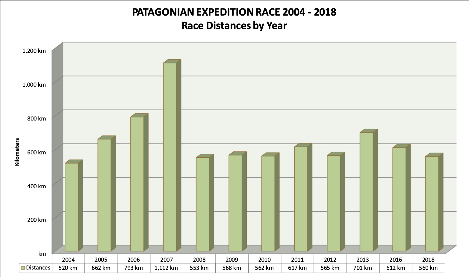
Graphic of race distances per year across the 12 editions between 2004 and 2018.
Race Times
Across the 12 editions, the average time for the winning team to complete the race has been 6 days and 17.9 hours. The last teams to cross the finish line have done so in an average of 8 days and 14 hours, while the average time for all teams to have reached the finish, across every year of the Patagonian Expedition Race®, is 7 days and 2 hours. The longest time on course for a winning team was 12 days and 10.5 hours in 2007, but this edition was a notable exception in the history of PER, as 1,112 km had to be covered and only one team managed to reach the finish line in Puerto Williams, Isla Navarino: the French team TSL-La Clusaz (Jerome Bernard, Cathy Ardito, Frédéric Charles and Laurent Ardito). However, the 2013 race was another long one, as the winners completed the 701 km race in 9 days and almost 7 hours: the British team Adidas Terrex (Nick Gracie, Mark Humphrey, Sally Ozanne and Chris Near).
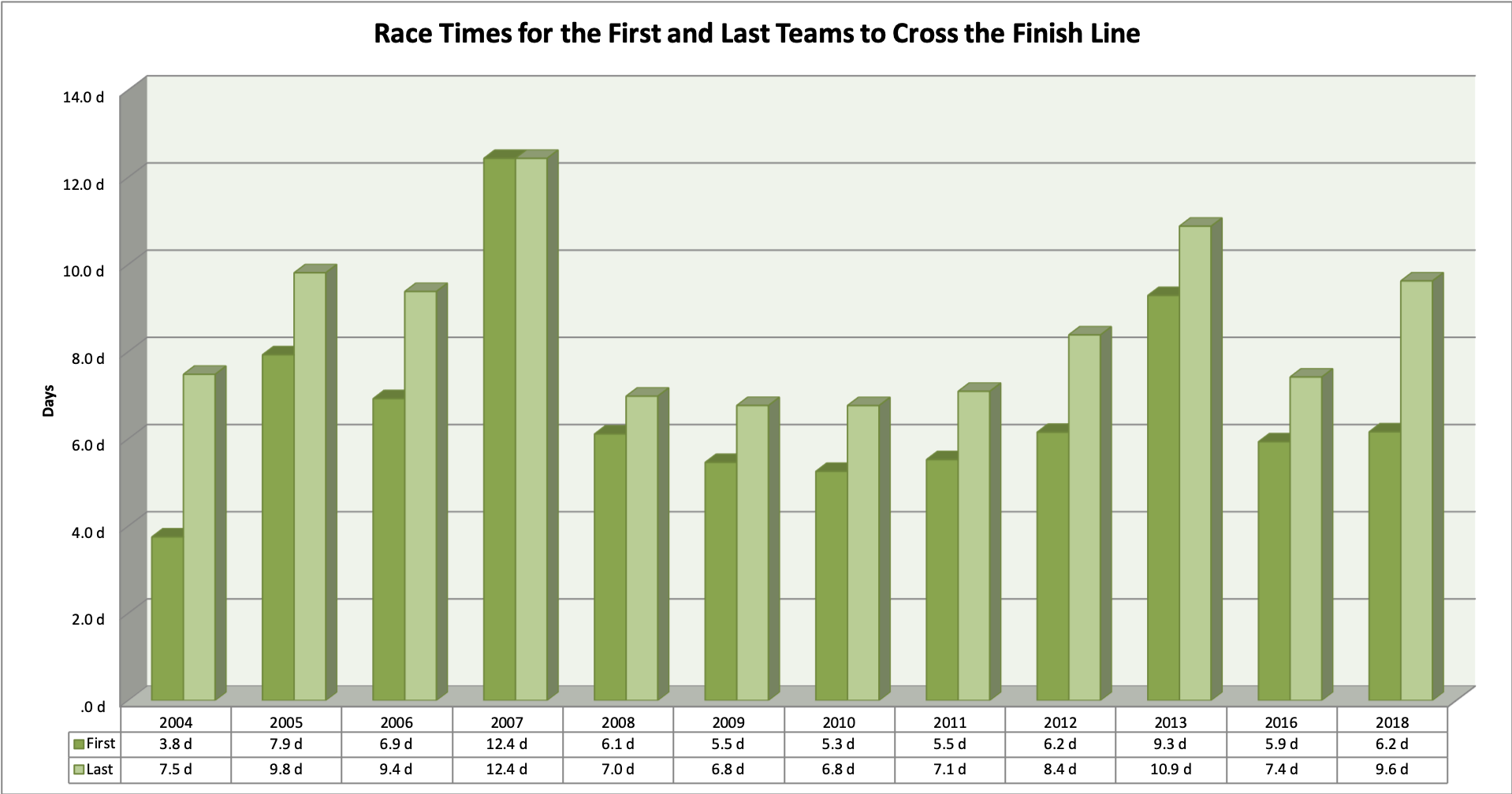
Graphic of race times per year for the first and last teams across the 12 editions between 2004 and 2018.
Finishers and Winners
In the 12 editions of the Patagonian Expedition Race®, 136 teams have participated, of which only 55% have crossed the finish line. The year with the greatest number of non-finishers was in 2016, when out of a total of 18 teams, only 4 managed to complete the race – just 22%. In contrast, the editions with the most teams to finish were in 2004 and 2018, where in both cases, out of the 10 teams participating, 8 managed to cross the finish line.
Throughout the history of the Patagonian Expedition Race®, bearing in mind that each team is made up of four members from any nationality, the country which has had the most first-place finishers is the United Kingdom, of which there are 20. Behind them is France, with 11 racers in first place, while the countries with the most people finishing in second place are Spain (15), Japan (12) and Canada (8). Furthermore, the country with the most members in any of the top three positions is the United States, with 25 reaching the podium. The following graphic shows the statistics of the winners per country and per athlete:
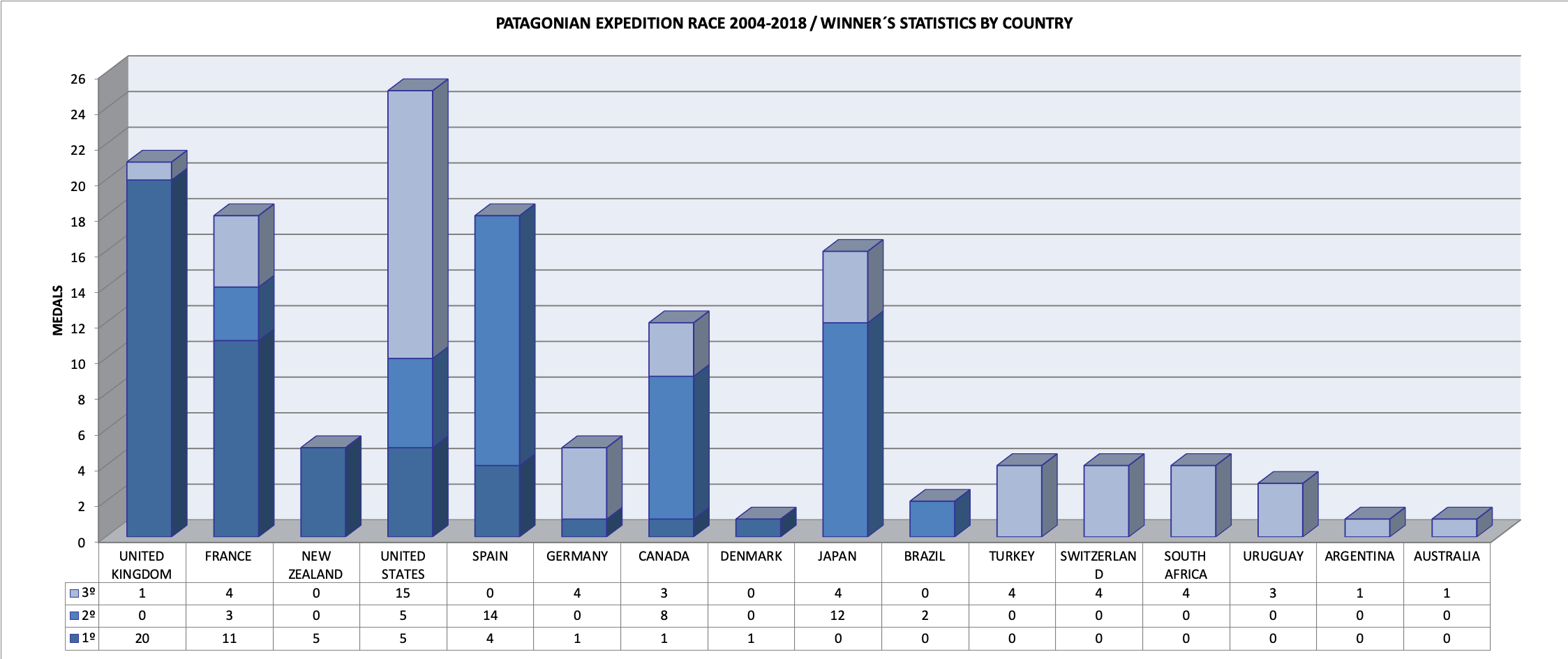
Graphic of winners per country for the 12 editions between 2004 and 2018. In this case, the nationality of each team member is taken independently.
Across all of the editions of the PATAGONIAN EXPEDITION RACE®, the runners who have most frequently been on the podium are the United Kingdom’s Mark Humphrey and Nick Gracie, with 4 first-place finishes, the North Americans Jason Magness and Chelsey Gribbon (2nd, 3rd, 3rd, 1st) and the Japanese Masato Tanaka (2nd, 2nd, 2nd and 3rd). Following them is Bruce Duncan from the UK (3x1st), Daniel Staudigel from the USA (2nd, 3rd, 3rd) and Yoki Takana from Japan (3x2nd). Other racers who have been on the podium twice include: Nicola Macleod, Andrew Wilson, Jerome Bernard, Laurent Ardito, Cathy Ardito, Frédéric Charles and Jari Hiatt (all 2x1st), Bruno Rey and Cyril Maragaritis (both 1st, 2nd), Urtzi Iglesias, Michitomo Yamakita and Saul Abril (all 2x2nd), Paul Cassedy (2x3rd) and Machiko Nishii (1st, 3rd). In the results section you can find the details for all of the editions.
SUMMARY 2004 – 2018
Below are tables explaining the sections and race distances for each edition of the Patagonian Expedition Race®, including the most important geographical references for each edition:
| PATAGONIAN EXPEDITION RACE® 2018 / Twelfth Edition / 20 – 30 November |
| PER 2018 – Disciplines | From | To | Geographical References & Notes |
| 1 | TRK | 55 km | Route Paine | Route Milodón | Cordón Chacabuco, Valle Tenerife, Cordon Prat, Paso Víctor Álvarez, Ultra Fiord Route |
| 2 | MTB | 116 km | Route Milodón | Fjord Obstrucción | Route Y-290, Milodón, Puerto Natales, Lake Pinto, River Primero, penetrating path to Fjord Obstrucción |
| 3 | TRK | 47 km | Fjord Obstrucción | River Nutria | Valle del River Pinto, Fjord Skyring |
| 4 | MTB | 147 km | River Nutria | River Canelo | River Verde, southeast coast of Seno Otway, River Grande |
| 5 | TRK | 89 km | River Canelo | Estrecho de Magallanes | Brunswick, south of Lake Parrillar, Monte Tarn |
| 6 | KYK | 40 km | Estrecho de Magallanes | Agua Fresca | Magallanes Strait, Fort Bulnes |
| 7 | MTB | 32 km | Agua Fresca | Tres Morros | 4×4 Access to Tres Morros |
| 8 | TRK | 34 km | Tres Morros | Punta Arenas | El Andino Ski Center |
| PATAGONIAN EXPEDITION RACE® 2016 / Eleventh Edition / 16 – 26 February |
| PER 2016 – Disciplines | From | To | Geographical References & Notes |
| 1 | TRK | 34 km | Faro (Lighthouse) Dúngenes | Estancia Los Pozos | Northern Coast of Magallanes Strait |
| 2 | MTB | 272 km | Estancia Los Pozos | Puesto Correa | Villa Punta Delgada, River El Zurdo, Estancia Laguna Blanca, Cacique Mulato, Villa Tehuelches |
| 3 | TRK | 76 km | Puesto Correa | River Primero | Altos River Pérez, Paso Hambruna, Fjord Obstrucción |
| 4 | MTB | 110 km | River Primero | Estancia Perales | Milodón, Puerto Natales |
| 5 | KYK | 6 km | Estancia Perales | Antonio Varas | Fjord Última Esperanza |
| 6 | TRK | 56 km | Antonio Varas | Last Hope | Península Antonio Varas, Cordon Moore, west Fjord Erezcano, northeast Fjord Worsley, Lake Azul |
| 7 | KYK | 17 km | Last Hope | Hosteria Balmaceda | Fjord Última Esperanza, Puerto Toro |
| 8 | TRK | 41 km | Hosteria Balmaceda | Estancia Perales | Ultra Fiord Route, Glacier Chacabuco, Paso Byron, Paso Abelardo, Valle River Tenerife |
| PATAGONIAN EXPEDITION RACE® 2013 / Tenth Edition / 12 – 22 February |
| PER 2013 – Disciplines | From | To | Geographical References & Notes |
| 1 | MTB | 108 km | Puerto Natales | Lake Grey | Route Y-290, Torres del Paine National Park |
| 2 | TRK | 118 km | Lake Grey | Estancia Mercedes | Ictiosaurios, Glacier Tyndall, Lake Geike, Monte Balmaceda, Lake Azul, Peninsula Antonio Varas |
| 3 | MTB | 38 km | Estancia Mercedes | Canal Señoret | Peninsula Antonio Varas |
| 4 | KYK | 24 km | Canal Señoret | River Hollemberg | Puerto Natales, Almirante Montt Bahía (Bay) |
| 5 | MTB | 44 km | River Hollemberg | River Primero | Lake Pinto, coast Fjord Obstrucción |
| 6 | TRK | 46 km | River Primero | River Pérez | Hambruna Pass, River Pérez |
| 7 | MTB | 161 km | River Pérez | Estancia River Caleta | River Verde, southeast coast of Seno Otway, River Grande |
| 8 | TRK | 91 km | Estancia River Caleta | Monte Tarn Summit | Brunswick, south of Lake Parrillar, Monte Tarn |
| 9 | KYK | 41 km | Monte Tarn Summit | Agua Fresca | Magallanes Strait |
| 10 | MTB | 30 km | Agua Fresca | Punta Arenas | Route 9 |
| PATAGONIAN EXPEDITION RACE® 2012 / Ninth Edition / 14 – 24 February |
| PER 2012 – Disciplines | From | To | Geographical References & Notes |
| 1 | MTB | 75 km | Punta Arenas | Voces Bahía (Bay) | Route 9, Agua Fresca, Fort Bulnes |
| 2 | KYK | 24 km | Voces Bahía (Bay) | Puerto Arturo | Magallanes Strait, Dawson Island, Fjord Owen, Canal (Channel) Whiteside |
| 3 | TRK | 76 km | Puerto Arturo | River Grande | River Cóndor, Lake Escondido |
| 4 | MTB | 140 km | River Grande | Karukinka (WCS) | Rusffin, Pampa Guanacos, Vicuña |
| 5 | TRK | 142 km | Karukinka (WCS) | Canal (Channel) Beagle | River Sánchez, Valley Profundo, Azopardo, Paso de las Nieves (Snow Pass), Paso de las Lagunas (Lakes Passing), Paso Glaciar (Glacier Pass) |
| 6 | KYK | 47 km | Canal (Channel) Beagle | Fjord Pía | Glacier Pía |
| PATAGONIAN EXPEDITION RACE® 2011 / Eighth Edition / 8 – 18 February |
| PER 2011 – Disciplines | From | To | Geographical References & Notes |
| 1 | MTB | 60 km | Hotel Las Torres | Lake Grey | Torres del Paine National Park, Lake Amarga, Lake Pehoe, River Paine |
| 2 | KYK | 47 km | Lake Grey | Monte (Mount) Balmaceda | River Grey, River Serrano |
| 3 | TRK | 73 km | Monte Balmaceda | Fjord of the Mountains | Lake Balmaceda, Témpanos, River Azul, Paso Profundo, Fjord Worsley, Puente de Roca |
| 4 | KYK | 58 km | Fjord of the Mountains | Bahía (Bay) Caribe | Fjord de las Montañas, north coast Peninsula Muñoz Gamero |
| 5 | TRK | 191 km | Bahía (Bay) Caribe | Puesto (Post) Las Nieves | Monte (Mount) Burney east, Lake Muñoz Gamero, Fjord Obstrucción, Fjord Skyring, River Blanco, Hambruna Pass |
| 6 | MTB | 188 km | Puesto (Post) Las Nieves | Pali Aike | Torres del Paine National Park, Lake Amarga, Lake Pehoe, River Paine |
| PATAGONIAN EXPEDITION RACE® 2010 / Seventh Edition / 9 – 19 February |
| PER 2010 – Disciplines | From | To | Geographical References & Notes |
| 1 | KYK | 8 km | Punta Delgada | Bahía (Bay) Azul | First Angostura Magallanes Strait |
| 2 | TRK | 16 km | Bahía (Bay) Azul | Tierra del Fuego | Northeast coast of Tierra del Fuego, Punta Baja |
| 3 | MTB | 110 km | Tierra del Fuego | Estancia Blanca Adriana | Y-65, Y-665, Y-725, River Óscar, Estancia China Creek |
| 4 | TRK | 55 km | Estancia Blanca Adriana | Bloque Errático | Cañadón Grande, Cueva (Cave) Tres Arroyos, Nómadas del Pleistoceno |
| 5 | MTB | 178 km | Bloque Errático | Lodge Lake Deseado | Y-895, Estancia River Chico, Estancia Las Flores, Pampa Guanacos, Vicuña (Karukinka, WCS) |
| 6 | TRK | 114 km | Lodge Lake Deseado | Bahía (Bay) Yendegaía | Valle Profundo (Deep Valley), River Azopardo, Paso de las Lagunas (Lakes Passing), River Lapataia |
| 7 | KYK | 46 km | Bahía (Bay) Yendegaía | Bahía (Bay) Wulaia | Canal (Channel) Beagle |
| 8 | TRK | 35 km | Bahía (Bay) Wulaia | Estancia Santa Rosa | Monte (Mount) King Scott, Finish Line northern coast of Navarino Island |
| PATAGONIAN EXPEDITION RACE® 2009 / Sixth Edition / 10 – 20 February |
PER 2009 –
Disciplines | From | To | Geographical References & Notes |
| 1 | KYK | 90 km | Lake Grey | Estancia Perales | River Grey, River Serrano y Fjord Última Esperanza |
| 2 | MTB | 91 km | Estancia Perales | Lake Pinto | Milodón, Puerto Prat, Puerto Natales, River Hollenberg |
| 3 | TRK | 50 km | Lake Pinto | River Pérez | Pared de roca (Rock Wall), Altos Estancia Skyring |
| 4 | MTB | 135 km | River Pérez | Rancho Sutivan | Cruce (Cross) River Verde, southern coast of Riesco Island |
| 5 | KYK | 82 km | Rancho Sutivan | Bahía (Bay) Isabel | Seno Otway, Fjord Wickhand, Lake Caballero, River Batchelor, Magallanes Strait |
| 6 | TRK | 114 km | Bahía (Bay) Isabel | Cabo Froward | River San Bernabe, River San José, River del Oro, River Nodales, Cruz de los Mares |
| PATAGONIAN EXPEDITION RACE® 2008 / Fifth Edition / 12 – 21 February |
| PER 2008 – Disciplines | From | To | Geographical References & Notes |
| 1 | MTB | 126 km | Porvenir | Puesto (Post) El Consejo | Vía (Track) Cordón Baquedano, Puerto Nuevo, Onaisin, River Marazzi |
| 2 | TRK | 18 km | Puesto El Consejo | Russfin | Intertwined section of pampas and woods |
| 3 | MTB | 27 km | Russfin | River Grande | Refugio Lake Escondido |
| 4 | TRK | 110 km | River Grande | Chorrillo Los Perros | Lake Escondido, River Cóndor, southern sedction of Lake Lynch and Lake Blanco |
| 5 | MTB | 57 km | Chorrillo Los Perros | Collado Genskowski | Lake Deseado |
| 6 | TRK | 46 km | Collado Genskowski | La Paciencia | Karukinka Mountains, River Sánchez |
| 7 | KYK | 25 km | La Paciencia | Fjord Parry | Fjord Almirantazgo, Bahía (Bay) Blanca |
| 8 | TRK | 60 km | Fjord Parry | Bahía (Bay) Yendegaia | Paso de la Muerte (Death Pass), Valley Lapataia, River Yendegaia |
| 9 | KYK | 30 km | Bahía (Bay) Yendegaia | Puerto Navarino | Canal (Channel) Beagle |
| 10 | MTB | 54 km | Puerto Navarino | Puerto Williams | Northern coast of Navarino Island |
| PATAGONIAN EXPEDITION RACE® 2007 / Fourth Edition / 11 – 25 February |
| PER 2007 – Disciplines | From | To | Geographical References & Notes |
| 1 | MTB | 148 km | Torres del Paine | River Golondrina | Porteria Serrano, Route Y-290, Milodón, Puerto Prat, Puerto Natales, Lake Pinto |
| 2 | TRK | 83 km | River Golondrina | River Nutria | Coast Fjord Obstrucción, east if River Azocar, coast Fjord Skyring, Bahía (Bay) Williams |
| 3 | MTB | 104 km | River Nutria | Cabo León | Cross River Verde, northern coast of Riesco Island, Rocallosa |
| 4 | TRK | 63 km | Cabo León | River Boer | Western coast of Lake Riesco, Rancho Sutivan |
| 5 | KYK | 310 km | River Boer | Puerto Arturo | Fjord Otway, Fjord Wickham, Lake Caballero, River Bachelor, Magallanes Strait, Canal (Channel) Gabriel |
| 6 | TRK | 28 km | Puerto Arturo | Puerto Yartou | Coast of Tierra del Fuego, River Cóndor |
| 7 | MTB | 200 km | Puerto Yartou | Lake Deseado | River Caleta, Cameron, Rusffin, River Grande, Pampa Guanacos, VicuñaVerde, northern coast of Riesco Island, Rocallosa |
| 8 | TRK | 92 km | Lake Deseado | Bahía (Bay) Yendegaia | River Azopardo, Lake Fagnano, River Betbeder, River Toledo, Paso de las Lagunas (Lakes Passing), River Lapataia |
| 9 | KYK | 30 km | Bahía (Bay) Yendegaia | Puerto Navarino | Canal (Channel) Beagle |
| 10 | MTB | 54 km | Puerto Navarino | Puerto Williams | Northern coast of Navarino Island |
| PATAGONIAN EXPEDITION RACE® 2006 / Third Edition / 12 – 23 February |
| PER 2006 – Disciplines | From | To | Geographical References & Notes |
| 1 | KYK | 60 km | Punta Dúngenes | Bahía (Bay) Posesión | Magallanes Strait |
| 2 | MTB | 233 km | Bahía (Bay) Posesión | River Rubens | Morro Chico, Estancia Berta |
| 3 | TRK | 63 km | River Rubens | Fjord Obstrucción | Estancia Berta, Estancia Lake Pinto, Escuela |
| 4 | KYK | 144 km | Fjord Obstrucción | Cabo León | Fjord Obstrucción, Paso de Indios (Natives Passing), Lake Muñoz Gamero, Fjord Excelsior, Fjord Skyring |
| 5 | TRK | 66 km | Cabo León | Rancho Sutivan | Western section of Lake Riesco |
| 6 | KYK | 50 km | Rancho Sutivan | Fjord Silva Palma | Seno Otway, Angostura Titus |
| 7 | TRK | 112 km | Fjord Silva Palma | River San Pedro | River Fariña, River del Oro, River San Nicolas, coast of Magallanes Strait |
| 8 | MTB | 65 km | River San Pedro | Punta Arenas | Route 9, River San Juan, Fuerte Bulnes, Agua Fresca |
| PATAGONIAN EXPEDITION RACE® 2005 / Second Edition / 12 – 21 February |
| PER 2005 – Disciplines | From | To | Geographical References & Notes |
| 1 | MTB | 95 km | Cerro Guido | Lake Grey | Parque Nacional Torres del Paine, Laguna Amarga, Lake Pehoe, River Paine, Lake Toro |
| 2 | KYK | 90 km | Lake Grey | Perales | Lake Toro |
| 3 | MTB | 91 km | Perales | Lake Pinto | Milodon, Puerto Prat, Puerto Natales, River Hollenberg |
| 4 | TRK | 91 km | Lake Pinto | River Pérez | Pared de roca (Rock Wall), Lake Pinto, altos de (upper streams of) River Pérez |
| 5 | MTB | 109 km | River Pérez | Rancho Sutivan | Cross River Verde, Southern coast of Riesco Island, River Grande |
| 6 | KYK | 50 km | Rancho Sutivan | Fjord Silva Palma | Seno Otway, Angostura Titus |
| 7 | TRK | 111 km | Fjord Silva Palma | Cabo Froward | River Fariña, River del Oro, River Nodales |
| 8 | KYK | 25 km | Cabo Froward | Faro (Lighthouse) San Isidro | Magallanes Strait |
| PATAGONIAN EXPEDITION RACE® 2004 / First Edition / 15 – 23 February |
| PER 2004 – Disciplines | From | To | Geographical References & Notes |
| 1 | MTB | 84 km | Porvenir | Puerto Nuevo | Tierra del Fuego, Cordón Baquedano |
| 2 | KYK | 64 km | Puerto Nuevo | Cabo Cameron | Bahía (Bay) Inútil |
| 3 | MTB | 71 km | Cabo Cameron | Puerto Arturo | Puerto Yartou, River Cóndor |
| 4 | TRK | 23 km | Puerto Arturo | Fjord Almirantazgo | Mountain Traverse |
| 5 | KYK | 57 km | Fjord Almirantazgo | La Paciencia | Fjord Almirantazgo |
| 6 | TRK | 117 km | La Paciencia | Bahía (Bay) Yendegaia | Lake Deseado, River Azopardo, Lake Fagnano, River Betbeder, River Toledo, Paso de las Lagunas (Lakes Passing), River Lapataia |
| 7 | KYK | 47 km | Bahía (Bay) Yendegaia | Puerto Navarino | Canal (Channel) Beagle |
| 8 | MTB | 57 km | Puerto Navarino | Puerto Williams | Northern coast of Navarino Island |